Horse Trek to Belukha


≈ 110 km

tent camps,
a small hotel


overnight


at the hotel

Departure from Ust-Kamenogorsk early in the morning Transfer to Zyryanovsk (Altai) in the very heart of Kazakhstani Altai.
Zyryanovsk was founded in 1791 to be a mine camp of the Altai mountain region. It happened after Gerasim Zyryanov found polymetallic ore deposit here. The village was named after his name. It started growing into the city only in 1833 and continued up to 1991.
In 1941-1945 (the Great Patriotic War) the State Musical Drama Theatre of Poltava was evacuated to Zyryanovsk. The city's economy has always been based on mining. In 1791, ore mining began at the Zyryanovsky mine. In 1892, the first industrial hydroelectric power station in Russia was built in Zyryanovsk on the Berezovka River. Despite the fact that the city is industrial, the cultural life of the townspeople did not go unnoticed. There are quite a few community centers which maintain different creative dimensions.
After a short tour around the town the next is a transfer to Katon-Karagai. We will have a picnic on the way. If you’d like to take a picture we can stop any time - the road is picturesque.
Katon-Karagai village was formed from two villages, but not Katon and Karagai. The two villages were only 2 versts from each other.
This is how a famous researcher, priest, Boris Georgiyevich Gerassimov refers to those places in his article “A Trip to Rakmanovskiye Mineralniye Klyuchi”
“Stanitsa Altaiskaya lays in the valley of the left-bank tributary of the Bukhtarma river. It is all covered in the green of gardens”. Irrigation canals purl along the streets. Amazing thick birch alley makes the village very attractive. The postal road from Ust-Kamenogorsk ends in the village of Altaiskaya, and is replaced further by zemskiy tract. The area where the village of Altaiskaya is located had previously belonged to China, but after the border was demarcated, it de facto became the possession of the Russian government. There is a church, a beautiful school building, a post office (Katon-Karagai), also, Altai forester office, medical personnel and veterinary supervision offices in Altaiskaya. The fair, which exists from December 6 to 19, is rumored to have a turnover of up to 250 thousand rubles ... The Katon-Karagai settlement is located two versts from the Altayskaya village. In the village there is a market place, a customs office, a school, a magistrate's cell, a hut on chicken legs with a signboard "Altai Arrest House". The peasant chief of the Ust-Kamenogorsk district also lives here. "
Currently, these two settlements form a single whole. However, unlike the beginning of the 20th century, the beginning of the 21st century can be characterized as a period of significant decline in Katon-Karagai. Before, there was a large number of houses, but now there are only grassy hillocks, many buildings are in ruins and make a painful impression. The Orthodox church is in the ruins too, a view of which opens immediately upon entering the village...

Upon arrival at Katon-Karagai there is dinner and rest at the local hotel.

per day ≈ 36 km.

at the hotel

ourselves

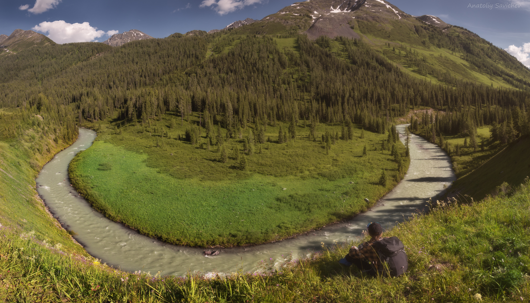
We’ll wake up early and have a substantial breakfast. We are going to have a busy day. Moving to Lake Yazovoye: This is the last outpost of "civilization" on the route—beyond it lie breathtaking views of untouched wilderness and nights under an endless starry sky.
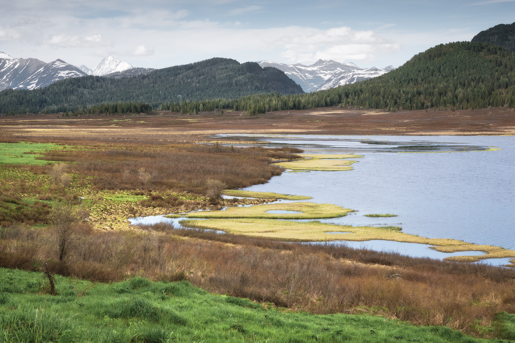
The lake is very popular among tourists seeking to get to the foot of Belukha, or to the very top. After all, it is located, perhaps, at the most popular trail in the area, leading to the lower camp of Kok-kol, which has lots of attractions.
The lake is about 3 km long, about 500 meters wide, and up to 10 meters deep. An interesting fact is that the water is surprisingly warm for a mountain lake situated at an altitude of about 1,655 meters above sea level. All thanks to the dark color of the water, and the muddy bottom. It is said that this is the only body of water in the southern Altai, where ide is found in abundance. Ide fishing , by the way, is allowed here.
In good weather you can get a good view of the two-headed mountain - Belukha - from the shores of the lake. Sometimes Belukha is reflected in the water surface of the lake.
The Yazevaya river flows out from the lake. About 5 kilometers downstream, there are several cascading waterfalls. They are called Yazevy waterfall.

At the lake, we leave our vehicles and saddle up. From here, the horseback journey to the base camp at the foot of Belukha begins. Around halfway, we will stop for a picnic lunch at the Sarsembai winter hut.

Winter hut is located in a wide valley on the right bank of the Belaya Berel river. A bit away from the old road which was used for tungsten ore transportation from the Kok-kol mine in the years of 1938 - 1954. Every year, in early summer, cattle is driven here from the Bukhtarma river valley, for the so-called fattening. By the end of summer, the livestock gains noticeable weight, as the surroundings are rich in natural forage.
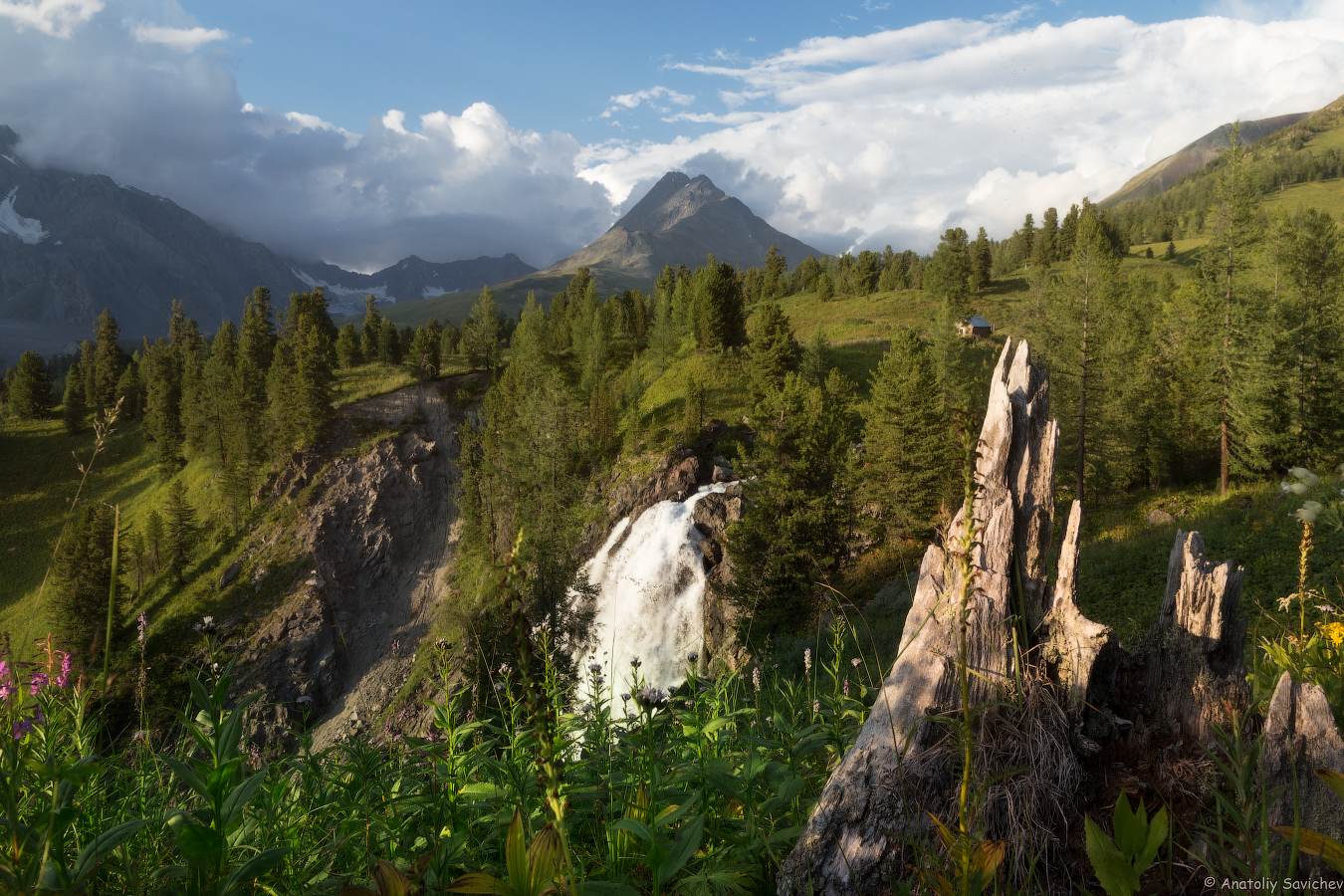
After a short break, we continue our journey toward the base camp, nestled in the wide valley of the Kokkol River. As we approach the camp, we will cross the ford of the Belaya Berel River. Then, after a short stretch of trail through the forest, we will catch our first glimpse of the stunning Kok-Kol waterfall.

A lot is connected with the name "Kok-kol". Translated from the Altai language, it means "Blue Lake". There are a lot of attractions named "Kok-kol” in the area where the waterfall is located. For example, the very lake from which the Bolshoy Kok-kol river originates, later flowing into the White Berel river. Not far from the lake, there are the ruins of a once operating mine, which is called Kok-kol too. Not mentioning a base camp of mountain climbers, located in the immediate vicinity of the waterfall. Can you guess its name? Kok-kol! Therefore, if you’re asked of where you are heading, you can simply answer - Kok-kol, and everyone will understand you without further ado.
The waterfall itself is a steep ledge with a height of about 80 meters, a steepness of about 60-70 °. A stream of water over 10 m wide rushes down from the wall of the Berel trough with a deafening roar that can be heard far far away. As the water cascades from the ledge, it splits into two powerful streams and several smaller rivulets. Crashing against the rocks, the torrents break apart, creating a stunning spectacle of roaring, swirling water. Falling into the bowl, water forms clouds of spray, which rise up and, illuminated by the sun, turn into a rainbow. Downstream of the waterfall, the bed of Bolshoy Kok-kol is obstructed with huge rocks and boulders that form rapids. There are several small waterfall cascades in this part of the stream. Some tourists managed to find Chinese writings and drawings on the rocks of the Kok-Kol waterfall.
What is this Kok-kol? This is Shambhala, this is Belovodye, at the beginning of the twentieth century Roerich himself was traveling not far from this place! There are a lot of unique attractions at this small area. Kok-Kol is piercing, to the very depths of the soul! And for everyone it is wonderful in his own way.
We will make a short stop at the waterfall and admire its power. Only a few minutes remain until we reach our campsite. This valley was once home to a settlement of around 200 houses, where workers would set out for their shifts at the nearby mine. Today, during the summer months, a large tent “town” springs up here, where travelers gather in the evenings for quiet conversations about the search for Shambhala, sing to the sound of a guitar, and share their impressions of the breathtaking beauty of the Belukha region.

After settling into our tents, we will enjoy dinner and a well-deserved rest.
per day ≈ 12 km.

ourselves
You don't need to get up early today, because we don't have to travel long distances. We will have breakfast in the camp, then go on a radial hike to the prayer stone. Our first stop along the way will be the unique Lake Tyoploye.
Actually, it is an unremarkable lake located about 3 kilometers from the lower camp of Kok-Kol. It is located on the left bank of the Malaya Kok-Kol river (1980 meters above sea level). The lake is about 1 kilometer long and just over 100 meters wide.
It is not more than 3 meters deep. Because of it the tempreture of the water is quite warm. It is said that even in winter, it does not freeze completely. The lake has naturally become a favorite spot for passing travelers. No matter where you're headed, taking a dip is a must!

After swimming, we continue the hike. The next place where we can recharge ourselves with Altai's "energy" will be a prayer stone. Weather permitting, we will arrange lunch with a magnificent view of Belukha.
There is another attraction not so far from the warm lake. It goes by different names: The Prayer Stone or Roerich's Sacred Stone. This stone is believed to hold powerful energy. They say that in the place where it lies, a very powerful energy column comes out. People come to this stone to bow to Belukha, pray for her, ask for the fulfillment of desires. Donations are left on the stone, in the form of sweets and various personal belongings. Roerich's followers believe that it was the place where he painted several of his unique paintings. Wishes made by the stone will definitely come true...

Having admired the dizzying landscapes of the Berel glacier and Belukha Mountain, we return back to the base camp. We can make another stop at the warm lake, or go to the Kok-Kol waterfall. Dinner at the camp.

per day ≈ 21 km.

ourselves
Breakfast at the base camp, then packing and preparation for the radial trek to the Kok-Kol mine.
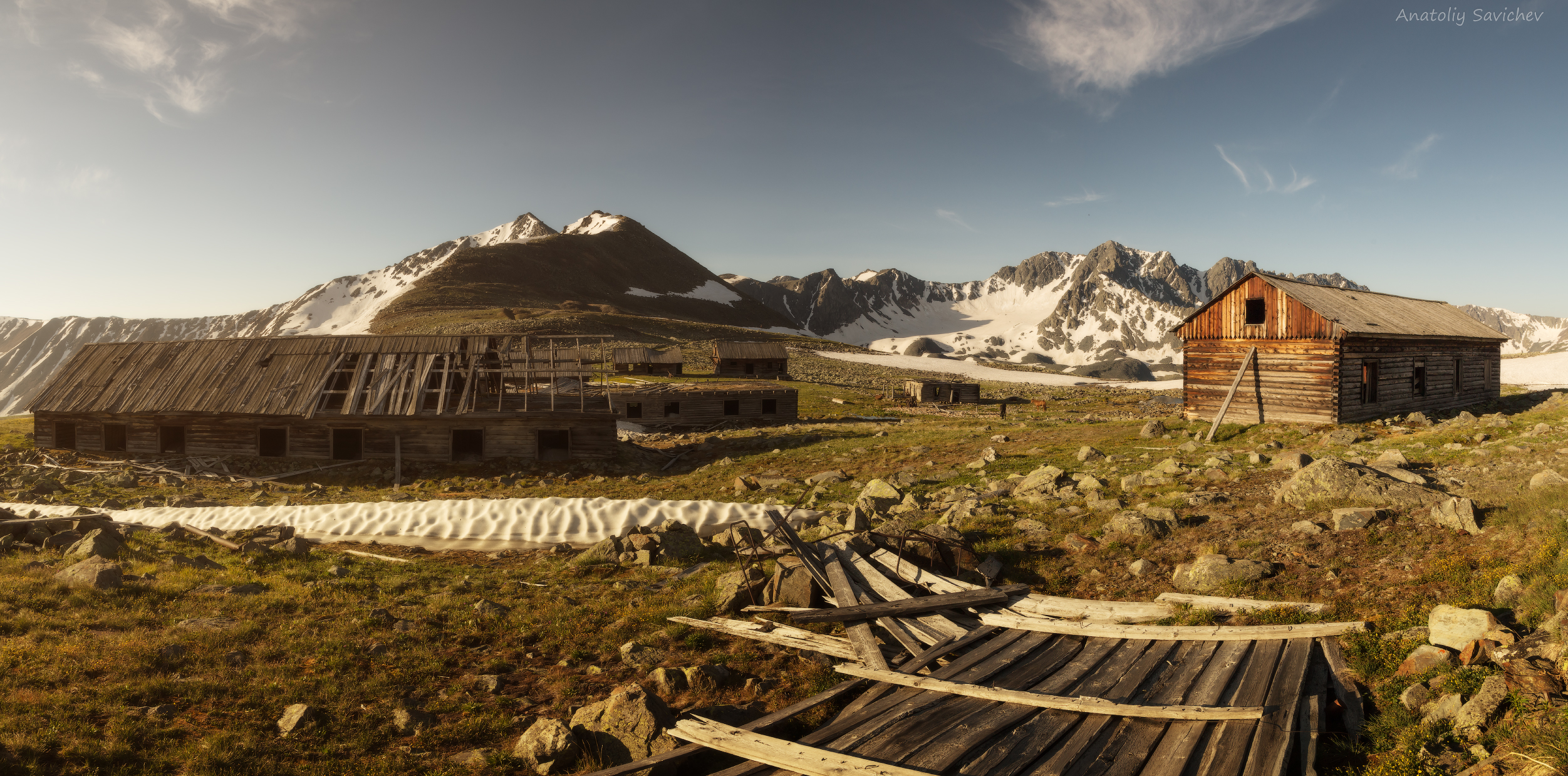
The place is truly strange, wrapped with many legends. An abandoned village in the mountain tundra, at an altitude of 2660 meters above sea level. with houses built of larch and scattered rusty mechanisms everywhere... For a long time, until 1954, there was a legend about prisoners sent here to work in inhuman conditions. Only after mine closure in 1954 many secrets and myths associated with it were dispelled. But the romantic halo around it has not diminished in the least, and this is completely justified.
This story began in the distant years of 1930s. In 1934, large-scale exploration work was organized for the exploration of the Kok-Kol tungsten-molybdenum deposit. The main difficulty of the exploration was that the field was located in an extremely inaccessible area and had no road communication, but only a horse trail. The local authorities were instructed to organize the transfer of about 200 tons of foodstuffs and, equipment to the deposit during the short summer period that makes the transportation possible - From June 1 to September 15, with the involvement of the required number of horses and camels.
Later, during the war years, the demand for tungsten-molybdenum ore increased, as it was essential for producing armor. As a result, all of the deposits, even the smallest ones, in the whole USSR were involved into the production of armor, and one of such deposits was Kok-Kol.

The mine was operated not by prisoners, but primarily by young men and women. Although the working conditions were not easy, the workers were considered free, but they could not leave the village and mine on their own. In awful conditions, they lived in summer and winter, worked 12 hours a day, mining ore in the most primitive way, almost no different from the one that was practiced 2000 years ago. The blastholes were made manually by 2 people, switching each other: one was holding the drill, the other was hitting it with a sledgehammer. Then the holes were filled with blasting material. The blasted ore was transported in barrows to the surface where it was sorted, processed and then, with great difficulties, sent to the “mainland”.
But youths are youths. Despite hard work, even in these conditions, they still found time to go to dances, admire the cosmic sky of the highlands and fall in love.

After the war, the mine was abandoned, and hastily, almost suddenly, abandoning the barracks and mechanisms. Even an old lonely Ford was left to rust - the memento of the military 1940s and early 1950s.

Exploration of the ruins left after the mine is quite an interesting activity and sometimes time just flies by. After visiting the ruins, we will have a picnic. Having a snack and a rest. If the weather is fine, you can make a short walk to the turquoise lake. The lake is quite large, deep and, of course, incredibly beautiful.
Then we will go back to the base camp, have dinner and rest. Dinner and rest.
ourselves
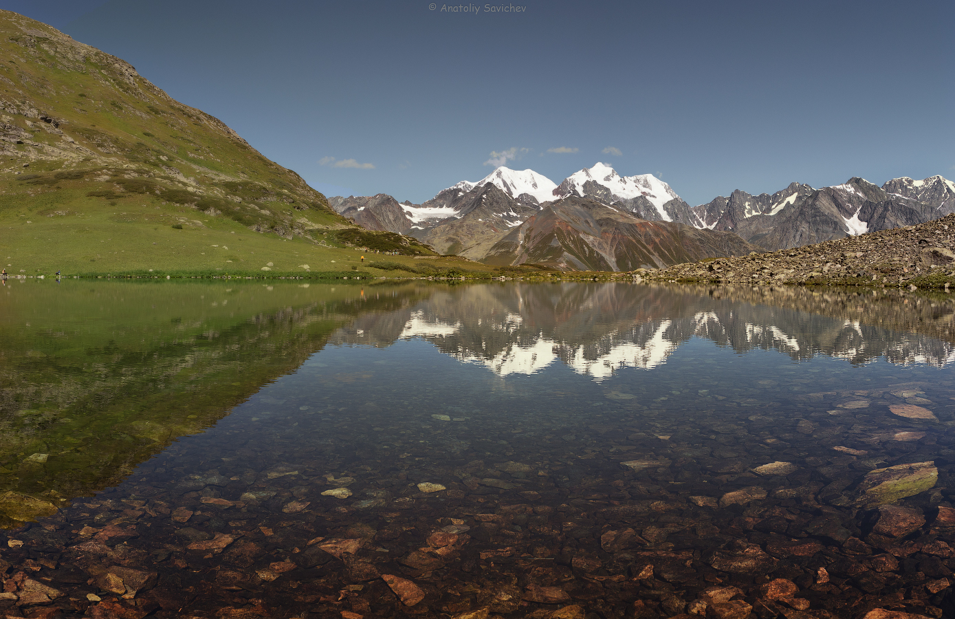
We’ll wake up early and have breakfast. Packing and preparation for a radial hike to Lake Ravnovesiye (equilibrium).
The lake itself is quite common. It is located at an altitude of about 2280 meters above sea level and is of glacial origin. A small glacier melted, leaving behind a popular lake. The water in it is so clean and transparent that on hot summer days it pulls into its icy embrace.
It is only 2 kilometers from the Kok-kol camp to the lake, but it takes different amount of time for every traveler to get there. Some get distracted by the endless lines of bushes of berries and mushrooms underneath.
On the lake you can often meet followers of Roerich, because in the water surface of the lake, which is almost always perfectly mirror-like, the Belukha massif and three peaks surrounding the lake are reflected. Faith, Hope and Love. Of this trinity, Love, by the way, is the most unapproachable. Everyone is looking for something of their own on the shores of the lake: some look for a beautiful landscape, some - for cosmic and other mystical forces...

At the lake, everyone can find something according to their interests. Some will go for a swim, some will meditate, others will just take a walk and admire the surrounding landscapes. In the evening we will return to the camp, have dinner and rest.
per day ≈ 30 km.

ourselves
Breakfast, packing. We saddle up and bid farewell to the base camp. The road to the Sarsembai winter hut is already familiar to us, where we will pause for an improvised picnic lunch. After lunch and a short rest, our journey continues along a rare and stunningly beautiful route. Once again, we will ford the Belaya (White) Berel River.

Having crossed the water barrier, we will climb a small pass, from where a wonderful view of Belukha opens. Next, we descend along an easy trail and cross another ford—this time over the Black Berel River, where we will spend our final night in tents on this journey.

The Black Berel is formed by the confluence of two smaller rivers—Little Black Berel and Big Black Berel. Big Black Berel, in its turn, originates high in the mountains and passes through a number of lakes, the largest of which is Lake Koskol. The Little Black Berel originates in a neighboring gorge at an altitude of 3,000 meters above sea level. This gorge is remarkable for its 13 alpine lakes nestled in its upper reaches. The Chornaya Berel River has several tributaries. The largest of them is the right tributary - the Arakan River, the source of which is Lake Koksu at 2062 meters above sea level.
The mountain ranges in the Black Berel Valley vary in height from 2,100 to 2,800 meters above sea level. 1.5 km upstream from where the Arakan River flows into the Black Berel, there is a cascade of waterfalls. The cascade is located within a kilometer of steeply dipping rocks. In some places the rocks form gaps - "pipes", where the river shrinks to 5--8 meters and rushes down with a roar. The cascade has about 15 small waterfalls and sinks. The rapids alternate with pits where the best grayling is found.

After a hearty dinner, we’ll gather around a campfire in a meadow under a star-filled sky. Rest.
per day ≈ 12 km.
cook ourselves
at the hotel
overnight

Breakfast and packing. On horseback, we ascend to Radostny Pass, where—weather permitting—we will have one last chance to admire Belukha Mountain.
The name of the pass was given by tourists, it is not official. The saddle of the pass is located at an altitude of about 2300 meters above sea level. In good, clear weather from the pass you can see Belukha, both of its peaks, a beautiful panorama of the Katunsky ridge, glaciers. And with very good binoculars, you can even see climbers going to the eastern peak of the Belukha. All this beautiful view evokes joy and delight, which is why the pass was called Radostniy (Joyful).

From the pass, we descend to Lake Rakhmanovskoye, nestled in the heart of the Altai Mountains. Here, the horseback portion of our journey comes to an end. We leave the horses behind and make our way to the lake. If you wish, you can take a leisurely walk along the shore, dive off the pier into the cool mountain waters, or bathe in a radon spring.

Locals say that the lake was named after a hunter named Rakhman, who lived and hunted in these lands long before they became popular. And he discovered miraculous springs in a quite interesting way. Once Rakhman went hunting. He hunted a beast for a long time. After tracking down the prey, he shot a maral, but he only managed to wound him. Where, a few days later, the hunter met him again, bathing in thermal springs. Rakhman was very surprised when he noticed that the beast was not even limping.
Later, in 1964, the Rakhmanovskiye Klyuchi resort started its work. It then became a popular place for recreation and health improvement in the East Kazakhstan region.
The lake itself is located in a narrow mountain valley, among the wooded slopes, at an altitude of about 1800 meters above sea level. The lake is about 2.5 kilometers long and just over 600 meters wide. According to various sources, the depth of the lake reaches 30 meters. The water in the lake, even on hot summer days, does not warm up by more than 15 degrees Celsius, but this does not discourage visitors from swimming at all. Especially after taking baths in natural, hot springs by the lake.
If you walk along the walking trail along the bank, you can come across mountain ducks nesting in the rock mass around the lake. It is especially interesting to observe when adult ducks bring ducklings to the water and teach them to swim.

After a picnic and a short rest, we get into our vehicles and begin the descent to Katon-Karagai. Upon arrival at the hotel—dinner and relaxation.


at the hotel
restaurant


Breakfast at the guesthouse, followed by packing up and a drive to Kazakhstan’s longest bridge over the Bukhtarma Reservoir.
The reservoir covers most of the Bukhtarma Basin and consists of two sections: The river section—following the Irtysh Valley.
Lake Zaysan, where the reservoir has expanded into a wide open water area. The reservoir area is 5490 km², length - 425 km, maximum width - 35 km, average depth 10 m. According to some sources, it is one of the five largest artificial reservoirs in the world. In the valleys of the rivers Bukhtarma, Narym and Monchekurskaya depression there are bays 30 to 50 km long and up to 10 km wide. The reservoir creates a deep-water route and improves the conditions for navigation of ships along the Irtysh. It is also used for irrigation. The filling of the reservoir began in 1960 with the help of the Bukhtarma hydroelectric power station dam.
After crossing the reservoir, we will enjoy a picnic-style lunch, followed by a drive to the city of Ust-Kamenogorsk. Upon arrival, we will have a final dinner at a restaurant and check into the hotel.


